1945 Map of the Watab Valley
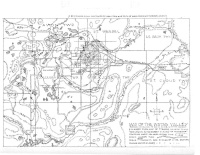
1945 Map of the Watab Valley by Fr. Cloud (Clodoald) Meinberg, OSB (1914-1982), “enlarged from map of Stearns County.” Published in Meinberg, Clodoald, “Sagatagan Saga,” Scriptorium, vol. 5, no. 2, Summer 1945, p. 25-38. [Map is between p. 28 and 29.] See http://cdm.csbsju.edu/cdm/ref/collection/SJUArchives/id/25132 for a description of the names of the lake’s features, going clockwise around Lake Sagatagan, by Fr. Cloud. See also his map of St. John’s property at http://cdm.csbsju.edu/cdm/ref/collection/SJUArchives/id/25138 [between pages 30 and 31].